
 EL PUENTE DE BACUNAYAGUA, LA OBRA MAESTRA DE INGENIERIA CIVIL DE LA REPUBLICA DE CUBA. PHOTOS. * THE BACUNAYAGUA BRIDGE, THE MASTERPIECE OF CIVIL ENGINEERING OF THE REPUBLIC OF CUBA. PHOTOS.
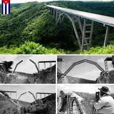
EL PUENTE DE BACUNAYAGUA, LA OBRA MAESTRA DE INGENIERIA CIVIL DE LA REPUBLICA DE CUBA.
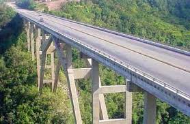
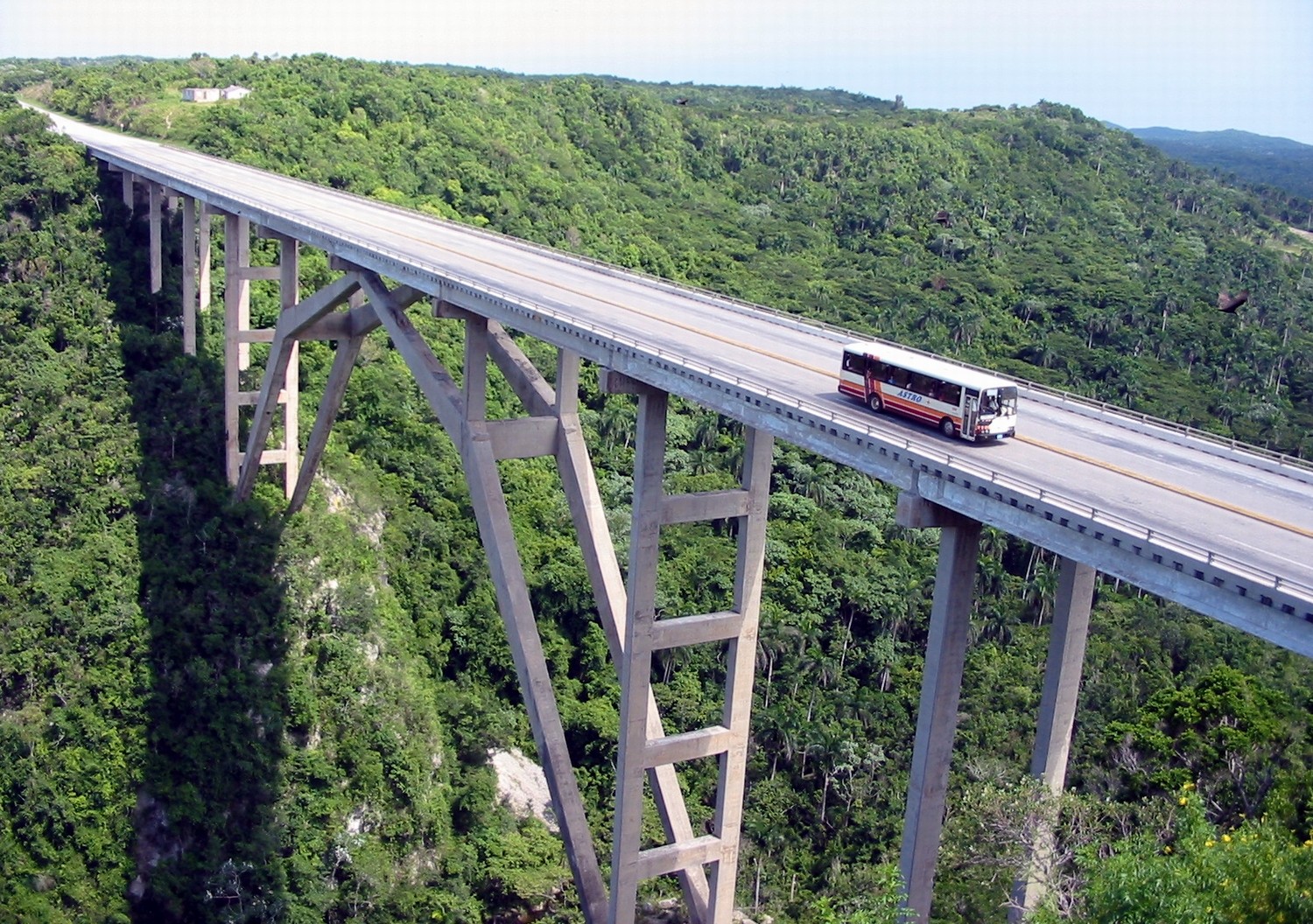
El puente de Bacunayagua es un puente cubano, que permite a la Vía Blanca cruzar el Valle de Yumuri.
Con la construccion de este espectacular puente Cuba tuvo la oportunidad de inaugurar el puente más largo y más alto en Cuba . Construido en las fronteras de la provincia de La Habana y Matanzas su construcción es históricamente un entrecruzado con la Vía Blanca ( la carretera que une Ciudad de La Habana y Varadero ), iniciada por el gobierno de Carlos Prío Socarrás ‘ , con el fin de acortar la distancia entre Matanzas y La Habana. Un total de 41 columnas sostiene el puente de Bacunayagua , los que estaban en su momento el más delgado del mundo hecha de hormigón .
El proyecto lo realizó la firma SACMAG (Sáenz, Cancio, Arvesu, Martín y Gutiérrez) y la ejecución del puente estuvo a cargo de ingenieros cubanos dirigidos por Luis Sáenz Duplace y Manolo Arvesu. Para la construcción del puente se buscaron ingeniosas y atrevidas alternativas debido a las condiciones del terreno sobre el que se erige.
Una de estas alternativas la constituye el uso por primera vez en Cuba de semiarcos, según la técnica del ingeniero austríaco Josef Melan, que fue inventor de “sistema de Melan”, método para la construcción de puentes reforzados. El uso del denominado arco es lo más novedoso del puente, ya que se construyó con acero laminado que se armó en dos partes, girando cada una hasta lograr la posición correcta.
CONSTRUCCION DEL PUENTE
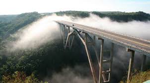
Con una extensión total de más de 313,5 metros, con una extensión del arco de 114 metros y a una altura de 103,5 metros sobre el nivel del mar y un ancho de 16 metros, se considera una de las siete maravillas de la ingeniería civil cubana.
En 1956 las obras de construcción del puente comenzó , clasificadas durante ese tiempo como una obra colosal, no sólo por su extensión , sino por la altura en un inmenso acantilado. Sus columnas poseen un montón de 22,50 metros cada uno , con una anchura de un metro por 1,60 metros , y algunas alcanzan los 42 metros de altura .
En sus almohadones hay 6 vigas que pesan cada uno 47 toneladas , y que se fusionaron en el mismo lugar el puente se estaba construyendo . En total, el puente tiene una altura de 103 metros , con una longitud 314 metros y una anchura de 17 . No le fue terminada hasta octubre de 1959, cuando la apertura de los caminos para la comunicación entre La Habana y Matanzas se liquidó oficialmente .
Este impresionante paso que se encuentra a 18 kilómetros al oeste de la ciudad de Matanzas y establece el límite territorial con la provincia de La Habana. Al norte del puente, el inmenso mar se divisa , el canal y la salida de lo que debería ser el lecho de un río caudaloso en un tiempo remoto, y al sur , el valle extenso y exuberante de Yumurí .
EL PUENTE DE BACUNAYAGUA
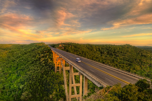
La importancia de ese cruce de la Vía Blanca reside en que es la conexión más cercana y directa, por el hermoso paisaje de la costa norte de Cuba , entre el túnel de la capital del país y el Spa Ciudad de Varadero.
La belleza del entorno de Bacunayagua , favorecida por la ejecución de ese proyecto avanzado , se alterna con multitud de cabos , laderas y manglares, refugio natural de gran importancia ornitológica donde 74 especies de aves conviven con 16 de reptiles y ocho de anfibios. En el ecosistema del pantano de esta área formaciones vegetales aparecen como el xeroformo costera salud y el bosque semideciduo , además de una rica y variada fauna con alto porcentaje de endemismo.
La magnitud y la espléndida imagen del lugar se pueden apreciar perfectamente desde el Mirador , ubicado en una elevación al oeste final de la obra maravillosa.
El impresionante puente constituyó desde 1976 hasta 2010 el límite territorial entre las provincias de La Habana y Matanzas, a partir de 2011 entre las provincias de Mayabeque y Matanzas.
Al sur del puente se puede divisar el Valle de Yumurí,al norte el lecho y la desembocadura de lo que debió ser en épocas anteriores un caudaloso río y un poco más lejano el mar.
Actualmente existe un mirador en la zona Oeste del puente en donde se puede apreciar tanto la arquitectura de este como la vegetación y la fauna en las zonas que lo rodean.

THE BACUNAYAGUA BRIDGE, THE MASTERPIECE OF CIVIL ENGINEERING OF THE REPUBLIC OF CUBA.
The Bacunayagua Bridge is a Cuban bridge, which allows the Vía Blanca to cross the Yumuri Valley.
With the construction of this spectacular bridge, Cuba had the opportunity to inaugurate the longest and highest bridge in Cuba. Built on the borders of the province of Havana and Matanzas, its construction is historically a crisscross with the Vía Blanca (the highway that connects Havana City and Varadero), started by the government of Carlos Prío Socarrás’, in order to shorten the distance between Matanzas and Havana. A total of 41 columns support the Bacunayagua Bridge, which were at the time the thinnest in the world made of concrete.
The project was carried out by the firm SACMAG (Sáenz, Cancio, Arvesu, Martín and Gutiérrez) and the execution of the bridge was carried out by Cuban engineers led by Luis Sáenz Duplace and Manolo Arvesu. For the construction of the bridge, ingenious and daring alternatives were sought due to the conditions of the terrain on which it is built.
One of these alternatives is the use for the first time in Cuba of semi-arches, according to the technique of the Austrian engineer Josef Melan, who was the inventor of the “Melan system”, a method for the construction of reinforced bridges. The use of the so-called arch is the most innovative feature of the bridge, since it was built with laminated steel that was assembled in two parts, rotating each one until the correct position was achieved.
THE BRIDGE CONSTRUCTION
With a total extension of more than 313.5 meters, with an arch extension of 114 meters and at a height of 103.5 meters above sea level and a width of 16 meters, it is considered one of the seven wonders of engineering. Cuban civilian.
In 1956, construction work on the bridge began, classified during that time as a colossal work, not only due to its extension, but also due to its height on an immense cliff. Its columns have a pile of 22.50 meters each, with a width of one meter by 1.60 meters, and some reach 42 meters in height.
On its cushions there are 6 beams that each weigh 47 tons, and which were fused in the same place the bridge was being built. In total, the bridge has a height of 103 meters, with a length of 314 meters and a width of 17 meters. It was not completed until October 1959, when the opening of the roads for communication between Havana and Matanzas was officially completed.
This impressive pass is located 18 kilometers west of the city of Matanzas and establishes the territorial limit with the province of Havana. To the north of the bridge, the immense sea can be seen, the canal and the outlet of what should have been the bed of a mighty river in a remote time, and to the south, the extensive and exuberant valley of Yumurí.
THE BACUNAYAGUA BRIDGE
The importance of this crossing of the Vía Blanca lies in the fact that it is the closest and most direct connection, through the beautiful landscape of the northern coast of Cuba, between the tunnel of the country’s capital and the Ciudad de Varadero Spa.
The beauty of the Bacunayagua environment, favored by the execution of this advanced project, alternates with a multitude of capes, slopes and mangroves, a natural refuge of great ornithological importance where 74 species of birds coexist with 16 species of reptiles and eight species of amphibians. In the swamp ecosystem of this area, plant formations appear such as the coastal health xeroform and the semi-deciduous forest, in addition to a rich and varied fauna with a high percentage of endemism.
The magnitude and splendid image of the place can be perfectly appreciated from the Mirador, located on an elevation at the west end of the wonderful work.
The impressive bridge constituted from 1976 to 2010 the territorial limit between the provinces of Havana and Matanzas, as of 2011 between the provinces of Mayabeque and Matanzas.
To the south of the bridge you can see the Yumurí Valley, to the north the bed and mouth of what must have been a mighty river in previous times and a little further away the sea.
Currently there is a viewpoint in the western area of the bridge where you can see both its architecture and the vegetation and fauna in the areas surrounding it.
Agencies/ Wiki/ InsightCuba/ Extractos/ Excerpts/ Internet Photos/ Arnoldo Varona/ www.theCubanHistory.com
LA HISTORIA DE CUBA/ THE CUBAN HISTORY, HOLLYWOOD.