

 THE TOA RIVER, Baracoa, Cuba: The largest and most powerful on the Island. PHOTOS. * EL RÍO TOA, Baracoa, Cuba: El más Grande y Caudaloso de la Isla. PHOTOS.
EL RÍO TOA, BARACOA, CUBA: EL MÁS GRANDE Y CAUDALOSO DE LA ISLA. FOTOS
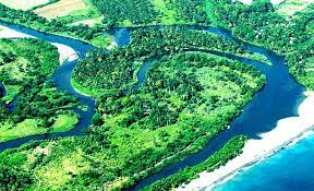
El río Toa es el río más caudaloso de la Isla de Cuba con 72 afluentes y aunque no nace en Baracoa, su sección transversal más marcada cruza por esta zona, y su longitud es de 131 kilómetros. Se ubica en la provincia de Guantánamo en el extremo oriental de la isla. Esta zona tiene uno de los pocos lugares de bosques con presencia de lluvias en el hemisferio norte.
La cuenca del río Toa ocupa alrededor del 70% de la Reserva de la Biosfera que lleva el nombre de Cuchillos de los Toa “Cuchilla del Toa”, esta constituye una de las regiones más importantes de Cuba y el Caribe, que viene dada por la valores de su diversidad biológica, la variedad de sus paisajes, la peculiaridad de sus ecosistemas y la alta presencia de especies endémicas en flora y fauna, constituyendo el refugio y centro de especies más antiguo de Cuba.
Esta cuenca es uno de los accidentes más notables del Grupo Ortográfico de Sagua-Baracoa, considerado desde el siglo pasado como “tierra incógnita”. Visitantes de todos los rincones del mundo son admitidos fascinados por las bellezas naturales que atesora y el estado de conservación de esa joya de la geografía mundial.
La cuenca del río Toa tiene una extensión de 1 061 Km2, una altura media de 488 msnm, pendiente media de 260 metros y una alta densidad del drenaje superficial (0,85 Km/Km2). Presenta una precipitación media de 2 630 mm/año, la más alta para una región de Cuba. Su principal corriente superficial es el Río Toa, el cual posee una longitud de 131 Km y presenta un alto deslizamiento anual cercano a los 57 m3/seg. Es aproximadamente la región menos habitada de Cuba, casi desierta, con un habitante por kilómetro cuadrado.
Su gran reserva de flora y fauna endémica es la más voluminosa del país que se conjuga con la existencia de una rica cultura autóctona. Existen mil especies de flores y 145 tipos de helechos. Esta fauna cuenta con aves en peligro de extinción como es el caso del Carpintero Real “Carpintero Real” y el Gavilán “Gavilán Caguarero”, el Tocororo, ave nacional de Cuba, también puede ser por estos lugares. El conocido “Almiquí” reconocido científicamente como el “Solenodon Cubanus”.
La UNESCO y el Gobierno de Cuba han declarado las siguientes áreas de la cuenca del Toa y sus zonas aledañas: Reserva Cupeyal Norte, Reserva La Melva y Reserva de la Biosfera de los Cuchillos del Toa “Cuchillas del Toa” como Reserva Mundial de la Biosfera .
Son propuestas por parte del Ministerio de Ciencia, Tecnología y Medio Ambiente (CITMA) como reservas naturales: Pico El Toldo, Pico Galano, Quibiján, Puriales de Cajuerí, Duaba y Yunque de Baracoa que ya es Monumento Nacional, todas en el Grupo de Sagua-Baracoa.
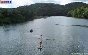
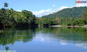
El río es uno de los mejor conservados del país debido al relativo aislamiento de la zona alta donde se ubica, altamente protegida. Rodeada por los bosques tropicales mejor conservados de la isla caribeña, es una importante región ecológica.
Esta Reserva de la Biosfera por la UNESCO alberga una gran cantidad de especies de plantas y animales en peligro de extinción, entre ellos el caracol terrestre cubano, que porta espirales de vistosos colores y cuyo diámetro es de unas dos pulgadas.

![]()
THE TOA RIVER, BARACOA, CUBA: THE LARGEST AND MOST POWERFUL ON THE ISLAND. PHOTOS
The Toa River is the mightiest and biggest river in the Island of Cuba with 72 tributaries and although is not born in Baracoa, its more marked traverse section crosses for this area, and its longitude is of 131 kilometers. It is located in the county of Guantánamo in the oriental end of the island. This area has one of the few places of forests with rain presence in the north hemisphere.
The watershed of the Toa River occupies around 70% of the Reservation of the Biosphere that takes the name of Knives of the Toa “Cuchilla del Toa”, this constitutes one of the more important regions in Cuba and the Caribbean, that comes given by the values of its biological diversity, the variety of its landscapes, the peculiarity of its ecosystems and the high presence of endemic species in flora and fauna, constituting the refuge and species center oldest of Cuba.
This watershed is one of the most remarkable accidents in the Orthographic Group of Sagua-Baracoa, considered from last century as “incognito earth”. Visitors of all the corners of the world are admitted fascinated by the natural beauties that it stores and the state of conservation of that jewel of the world geography.
The watershed of the Toa River has an extension of 1 061 Km2, a half height of 488 msnm, half slope 260 meters and a high density of the superficial drainage (0.85 Km/Km2). It presents a half precipitation of 2 630 mm/year, the highest for a region in Cuba. Their main superficial current is the River Toa, which possesses a longitude of 131 Km and it presents a high near annual glide to the 57 m3/seg. It is approximately the less inhabited region of Cuba, almost deserted, with an inhabitant for square kilometer.

Their great flora reservation and endemic fauna is the most voluminous in the country that is conjugated with the existence of a rich autochthonous culture. A thousand species of flowers and 145 types of ferns exist. This fauna has birds in extinction danger like it is the case of the Real Carpenter “Carpintero Real” and the Sparrow Hawk “Gavilán Caguarero”, the Tocororo, national bird of Cuba, it can also be for these places. The well-known “Almiquí” scientifically recognized as the “Solenodon Cubanus”.
UNESCO and the Cuban Government has declared the following areas of the watershed of the Toa and its closes areas: Cupeyal North Reserve, The Melva Reserve, and the Reserve of the Biosphere of the Knives of the Toa “Cuchillas del Toa” as World Biosphere Reserve.
Are proposed by the part of the Ministry of Science, Technology and Environment (CITMA in Spanish) like natural reservations: Pico El Toldo, Pico Galano, Quibiján, Puriales de Cajuerí, Duaba and Yunque of Baracoa that it is already National Monument, all in the Group of Sagua-Baracoa.
The river is one of the best preserved of the country due to the relative isolation of the area where it is located high, highly protected. Surrounded by the best preserved tropical forests of the Caribbean island, is an important ecological region.
This Biosphere Reserve by UNESCO holds a large number of species of plants and animals in danger of extinction, including the Cuban land snail, who wears brightly colored spirals and whose diameter is about two inches.
Agencies/ Wiki/ Cubaaism/ Extractos/ Excerpts/ Internet Photos/ Arnoldo Varona/ www.TheCubanHistory.com
THE CUBAN HISTORY, HOLLYWOOD.

![]()